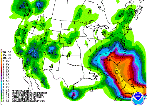
Projected rain amount to accumulate over the next 5 days through Sept. 15. Provided by Howard Diamond and NOAA.
Over the past few days, Hurricane Irma ripped through the Caribbean, killing at least 18 people and leaving devastation in it’s wake. Now, as the hurricane heads towards South Florida, thousands of people are attempting to escape the storm.
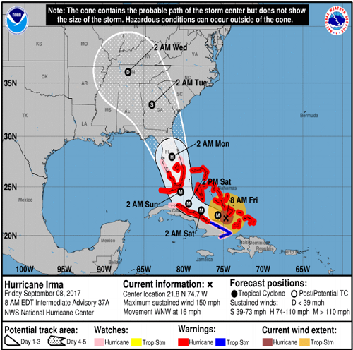
Yesterday, Irma was downgraded to a category 4 hurricane, but could still do serious damage to Florida homes. In a report compiled by Robert S. Young, Director of the Program for the Studies of Developed Shorelines and Professor of Coastal Geology at WCU, Florida will experience “hurricane force winds, tornadoes, and severe thunderstorms over a 36-hour period.” According to the report, it isn’t likely that Florida will experience widespread flooding, most of the damage will be caused by the wind.
After NC Gov. Roy Cooper declared a state of emergency, Cullowhee residents are anxious on how to prepare. Irma is expected to hit Jackson County on Monday evening.

Hurricane Irma’s projected path. Provided by Robert. S. Young.
According to the Director of the World Data Center for Meteorology in Asheville, Howard Diamond, Cullowhee may be able to “expect some heavy rain (not sure how much) on Monday evening; but certainly not the kind of conditions that people have seen with either Hurricane Harvey in Texas, or will see in Florida in another day or so with Irma.”
Currently, it’s too soon to tell how exactly Irma will affect Cullowhee, but Diamond urges residents not to panic. “Frankly, I do not believe that there is anything for folks in your area to panic about,” Diamond said. He is also suggesting to pay attention to the weather channel and to any possible watches or warnings that are issued for Cullowhee.
As of now according to an email from Provost Morrison-Shetlar, the WCU campus will be open on a normal schedule. If the weather report changes, WCU will “follow the university’s Adverse Weather Policy (Policy #41) to make determinations on class and work schedules.”
You can view the forecast track for Irma as well as the other two active hurricanes in the Atlantic: Katia and Jose, here.


